
As fulmars cry in the distance
And the wind rocks my stance
I am one with the cold breeze
I am north
And I am home
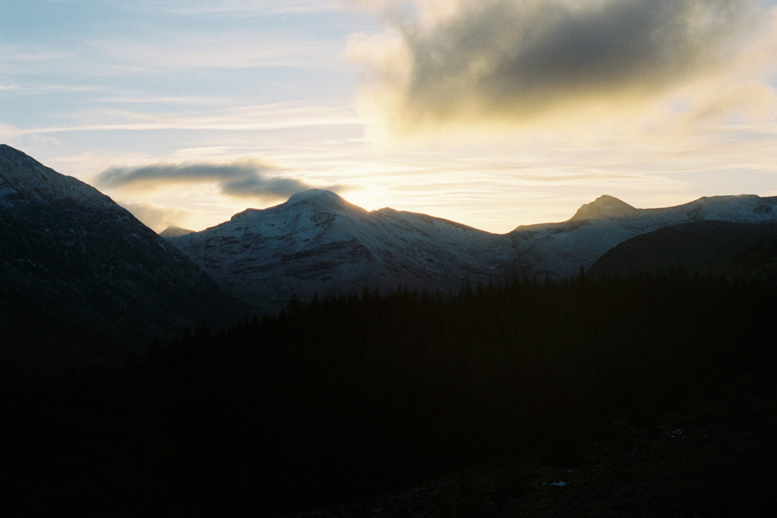
I moved to Scotland at the end of a hot summer. In the months that followed I saw the days darken and the landscape change colour, taking on deeper hues. All the while, I sought further and further corners of this land, where nature is in charge, and the weather leaves its mark on the landscape.
For some time I’d had my eye on an archipelago in the middle of the Atlantic Ocean, more than 200 km off the coast of Britain. The Shetland Islands are the northernmost territory of Scotland and are closer to Bergen in Norway than to Edinburgh. You cannot go further afield in Scotland.
Shetland is separated from the mainland by the North Sea, but also stands out from the rest of Scotland in culture and history. Up until the 15th century, Shetland was part of Norway, and the Norse influence is reflected in most place names. Gaelic has never been the main language here, and much of what makes the Scottish identity – clans, kilts, cèilidhs – isn’t tradition here. Shetlanders are a farmer- and fisherfolk, islanders, hardened and self-sufficient. They’ll call themselves Shetlander in the first place, and then Scot. No wonder, when you see their distance from the rest of Scotland.
It is precisely the isolation that drew me to Shetland. What moved the Vikings – and the Picts long before them – to settle on this barren strip of land, cut off from the outside world by waves and howling wind?

Everyone who travels to Shetland will feel this wonder, but I decided to take it one step further, and make the journey in January, when the sun stays up for less than 7 hours and the landscape has lost its last bit of colour.
If you aren’t put off by rain and wind (you cannot avoid those, even in summer), and are content with the limited daylight, visiting Shetland in winter is doable (provided that you have a car). I’d even say that the emptiness and silence of the islands make a trip that much more special. It brings you closest to Shetland in its wildest state.
The crossing
The journey starts with a 16 hour long ferry trip over the North Sea from Aberdeen. It’s possible to fly to Shetland, but this is a lot more expensive. Besides, the crossing itself is a whole experience, especially in winter: for a night you are one with the waves, and your first sight of the archipelago is upon docking at the harbour at the break of dawn.
In winter you're lucky if you reach Shetland without struggle – the sea is often too wild to make the crossing, and if you do make it on board you'll be gifted with some sweet seasickness.
A few days before departure we’re still not sure our trip will go ahead; the forecast is turbulent. But Shetlanders are stubborn and will brave the highest waves they can; for them this ferry means groceries, medicine, their line with the rest of the world. And so, on January 19th, we sail onto a wild North Sea. While we stagger across the ship – every wave throws us further out of balance – they drink beer & laugh, sitting on chairs anchored to the floor, untroubled by the world that sways around them. It seems we’re the only strangers here.

We all have our own reasons to come here; the waves, the cliffs, the seclusion… For my friend Nick it’s the crossing itself that makes his heart beat faster. So at night, we are glued to the round window of our cabin, watching the waves crash into us. On deck, we hang over the railing, gasping for air – the waves fly up well above the roof of the ship!
After a restless sleep the captain wakes us at 7 in the morning. Land ahoy! Drowsily, we get up and pack our things. When we set foot on land, the island is still shrouded in darkness, but a deep pink hue is spreading out across the sky. Shetland is still asleep, except for the fulmars – they are raging around us. As they will do continuously in the coming days.

Day 1: Mainland
After we’ve picked up our rental car and checked into our hostel, Islesburgh House Hostel – a fine hostel, and open year-round – we look for breakfast. We find it at Fjarå, a cafe on the shore. It becomes our regular spot on this trip. Balancing on rocks, we watch the sun rise behind rough waves. Hypnotised by the swell, like the seals, that each make a brief appearance near the shoreline. They have nothing to fear here.
Then we hit the road. Rest is for later, in the long evening hours – first we make the most of the daylight. We drive away from Lerwick, to the cliffs in the west, nearby Westerwick. As soon as we’ve left town, it’s as if we’ve arrived at the end of the world. Endless, gently rolling hills, sheep fields, the occasional farm. It goes on like this with every turn we take, there’s not a single soul on the road. And always the vicinity of water; voes, and sea where the land ends. Water as far as the eye can see.
In a week, Lerwick will celebrate Up Helly Aa, a large fire festival that honours the Norse history of Shetland. People from all around the world will flock to the islands. When my friends and I realised we’d miss the festival by a week, we were disappointed, but as we drive through the deserted hills, I’m glad we’re here now.

The cliffs of Westerwick can be hiked from Silwick, on the end of a narrow single-track road. There’s nothing here but a big barn, not even a real parking space. In summer the place fills up with people – Westerwick is one of Shetland’s most beloved views – but today there’s no sign of life. We wonder whether we’re even meant to cross the fence to follow a vague mud trail leading up the hill behind the barn. But my navigation really points me in this direction. It turns out to be right. Soon enough the first cliffs come into view, with granite stacks jutting out of the sea, their outline as jagged as a mountain range.
The coastline of Shetland is characterised by geos: deep, narrow clefts that cut into the coastline, shaped by waves eroding into the rock faults. They give the coast an unusual intimacy: every geo is a world of its own, that you become part of for a moment. There’s so much to see – screeching fulmars, the crystal clear sea down below, an unreachable strip of sand.


The trail we follow isn't much of a trail. First we follow a fence above the abyss; later, when it vanishes, we frolic freely over the cliff edges, the sound of wind and fulmars in our ears. We wander off to a cape that reveals a panorama of the coastline. On each side, stacks and crags stretch out into the distance.
We descend towards Westerwick and the sun breaks through. All of a sudden, several seals plunge into the water below us. They had been sunbathing on rocks along the shore, camouflaged from our eyes. We are being spoilt with wildlife today. That’s what the winter gives us.
We are enjoying ourselves so much that we only manage to complete half of the trail. Before we reach the houses of Westerwick, we turn back around – our time on Shetland is limited, and there’s much more we want to see on the Mainland.


We drive all the way to the southern tip of the island. Here lies Shetland’s most impressive archeological site, at Jarlshof.
In the 19th century, Jarlshof was exposed by a storm, and since then, evidence has been found here of thousands of years of human settlement, dating back as far as the Bronze Age; a broch and wheelhouses, Pictish stones, a Viking longhouse. The young English museum keeper tells us all about it and she’s got all the time in the world; we are the only visitors today.
What makes Jarlshof unique is that you’re free to wander through the intact passages and chambers, so you get a real sense of what life was like here many centuries ago. We have to bend down in most places; the round chambers, overgrown with grass, are like hobbit homes. The stacked stones look so fragile, I’m afraid to knock them over with my touch; but these houses have withstood millennia for a reason.
From the lookout it becomes apparent just how extensive the site is. There’s a wistful beauty here; the green, green grass, the sparkling waves in the setting sun. No wonder Walter Scott picked this place as backdrop for his novels.
You can make a fine coastal walk from Jarlshof to the lighthouse on Sumburgh Head, which marks the sourthernmost point of the mainland. But it’s 15:00 and time is running out, so we grab the car for the last stretch to the lighthouse. Here we encounter two other tourists for the first time.

The sun has stayed with us and slowly turns the sky orange. Again there’s hundreds of northern fulmars, now circling above a slanted sandstone cliff. It might be the one downside to a winterly visit to Shetland: in summer, thousands of razorbills, guillemots, kittiwakes and puffins nest here. In winter, only the fulmars remain. But they bring enough spectacle!
We climb onto the lighthouse, that sits dramatically on the cape. East, west, and south is sea. On a clear day you can see over to Fair Isle on the horizon, just as you can see her from the northernmost island of Orkney. It must have been the lifeline for the first settlers here, their only testimony of a world beyond the isles.

Then we face a choice: what to do with our last 20 minutes of daylight? We can stay on the lighthouse and watch a peaceful sunset, but our lust for adventure isn’t over yet. In the last sunlight we go to St Ninian’s Beach, a short drive back north. We pass by Sumburgh Airport, and strangely enough we don’t drive around, but over the runway – the peninsula is so small we simply cannot go around it. Would this be possible anywhere else on earth?

St Ninian’s Beach is a remarkable beach: it’s a tombolo, locally named ayre, a sandy isthmus that connects tiny St Ninian’s Isle to the mainland. Tombolos are characteristic of Shetland’s landscape, that has been sinking further and further under water since the last Ice Age. At high tide in winter, the beach is sometimes washed away completely; right now the tide is out and we can walk over the strip of sand to the island. On both sides, we can hear the waves crash into the shore. It’s as if we’re standing in a no man’s land between two worlds.
It’s almost dark when we climb onto the islet. A grassy hill, where an old lady is walking her dog. St Ninian has a ruined chapel, where a treasure of Pictisch silver and a porpoise jawbone were found, but we couldn’t find it in the twilight. It’s the perfect place to finish off the day, running over the grass under a purple sky, looking out over black rocks in a rippled sea.
Back in Lerwick we go on the hunt for food and beer. It’s early evening, but the town follows the rhythm of the sun; the streets are deserted. Eventually, we find a pub where most islanders seem to have gathered. The pubgoers glance at our outdoor clothes and our strange accents – this is very much an island indeed.
Day 2: Yell & Unst
On Saturday we are on the road before dawn. Our destination today is the northernmost point of Shetland – and the whole United Kingdom. To get there we need to take two ferries, first to Yell, and then to Unst, Shetland’s northernmost island. It’s a logistic puzzle, and we’ll be on the road for most of the day, but it will be the highlight of our trip.
The sea is shaking and gushing; we stay safely between closed car doors. From the main road, Yell appears an utter beak and bare place; yet even here, there are houses on every corner. Incredible, the places where men have settled. But behind the barren moorland lies a wild coastline, with cliffs and untouched coves, where otters roam. An hour before our next ferry isn’t enough to do this island justice.
We pay a short visit to the beach of West Sandwick. The wind is strong today. Waves splash against the rocks. Salt breeze on red cheeks. My friend Giada is a surfer and observes the swell, her eyes full of longing.

The small Hillshop in Mid Yell sells food and coffee all throughout the year – lucky for us! Cold fingers clutch warm cups. The sky remains restless. Now again rain pours down on us as we run from doorway to car.
Traffic grows sparser and sparser. We cross over to Unst, and hit the last road, that leads us to the furthest end of the British Isles. Unst has many places of interest, if only because they’re the most northerly of their kind – the northernmost village, northernmost beach, and northernmost point.

The latter is located near Hermaness, at 200 meters not a high hill, but a windy one all the same. You have to go over the hilltop to get a view out to a chain of rocks in the sea with a white lighthouse on top, Muckle Flugga. The furthest rock is called Out Stack; this is the actual northernmost point of Scotland, but for humans it’s virtually impossible to dock here.
Hermaness is as close to Muckle Flugga as we can get. It’s a protected nature reserve; every year thousands of birds nest on its spectacular sea cliffs. In summer it’s an infernal racket of birds, now it’s quiet, if it wasn’t for the wind.


The wind that sticks our jackets to our skin and freezes our bare cheeks; the wind that chases life away and throws waves against the cliffs. Over the crest of the hill Muckle Flugga comes into view, that has stood for over 150 years, alone and exposed, on the only flat patch of a sloping outcrop. In winter the waves sometimes strike over its 60 meter summit. There couldn’t have been a more fitting location for the most northerly end of the wild land that is Scotland. And we’re all alone here.
I go slightly off-trail to get a better shot of Muckle Flugga on my camera. And suddenly I see a promontory at the bottom of the grassy slope of Hermaness, where dozens of sheep are grazing. There’s something magical down there that draws me in; what it is I don’t know yet.
Sidenote: during the breeding season between April and August it’s advised to not stray off the paths to avoid disturbing nesting birds.
Pepijn, Nick and Giada come with me. The further we descend, the more is revealed of the dream world that lurked around the corner, that we’d have missed, if it wasn’t for my slight diversion. On the headland we come face to face with the waves that crash against the cliffs relentlessly. Cliffs with deep cracks that bear witness to the millions of years of storm that have chafed them. Nick is overjoyed. The sea is clear blue where the waves foam, a colour so bright it’s almost tropical. Who would have thought that possible in a place like this?
And behind the promontory there’s a sheltered bay with dark rocks and a grass so green, where sheep are frolicking. The bay seems to have escaped the harsh spell of winter entirely. It reminds me of the colours of Iceland, so fertile despite its harsh climate.
We scramble down mud and grit to a tiny beach that is nestled between the moss and the slanted black cliffs. The big boulders we’re standing on are the last thing that connects us to Scottish soil. We can touch the waves. Sea water splashes in our face, and we look north, endlessly north. Nothing but sea till the North Pole.

For a moment, we’re the northernmost people in Scotland.

Storm makes way for reluctant sun rays. We climb back, south over the clifftops, and pass by a sea arch and the pointed cliffs of the Neap. They’re breathtaking in the setting sun.
Our trail vanishes in the moors, so we have to go straight through the blanket bog, to the other end of the peninsula where our car is parked. It’s an unpleasant retreat – wet feet and horizontal rain and all. But it doesn’t really matter, after the secret glory we’ve just seen.
Day 3: Scalloway & Lerwick
On our last morning we want to have brunch in the center of Lerwick, but it’s sunday and almost all shops are closed. So once again, we end up at Fjarå.
A short drive from Lerwick is Shetland’s second town, Scalloway. The main sight here is Scalloway Castle, the tower house of the cruel earl Partick Stewart in the early 17th century. In the pouring rain we stand in front of a fenced ruin – unfortunately the historic site is closed for conservation works.
Instead, we hide from the rain in the Shetland Museum, an educational museum about Shetland’s geology, history and culture. It’s a bit youthful, but it’s fun to learn about the geology of the places we’ve visited these past days.

Then the sun goes down again, and it’s time to get aboard our ship. My friends will return to Aberdeen, I stay behind in Kirkwall, for a solo adventure on Orkney. Full rucksack on my back, I take a last look at the lights of Lerwick, that get Shetland’s people through the dark winter, year after year. It’s not a place I shall return soon, hundreds of kilometers from the continent. But what an amazing corner of the planet it is. I know no place whose isolation is so deeply rooted in its people, and landscape.

Leave a Reply